Gifting Made Simple
Too many options? Click below to purchase a Coquitlam Centre eGift Card that can be used at participating retailers at Coquitlam Centre.Purchase HereHome
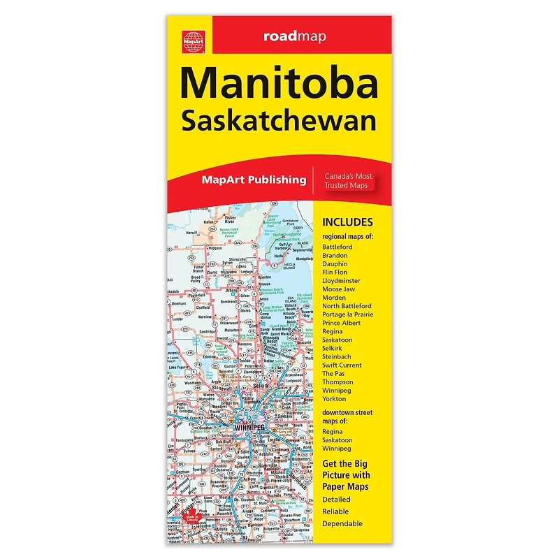
Manitoba Saskatchewan Folded Map
Walmart
Loading Inventory...
Manitoba Saskatchewan Folded Map in Coquitlam, BC
By MapArt
Current price: $7.95
Walmart
Manitoba Saskatchewan Folded Map in Coquitlam, BC
By MapArt
Current price: $7.95
Loading Inventory...
*Product information may vary - to confirm product availability, pricing, shipping and return information please contact Walmart
Manitoba Saskatchewan Folded MapFolded maps have been the trusted standard for years, offering unbeatable accuracy and reliability at a great price. Detailed indices make for quick and easy location of destinations. It’s a must-have for anyone travelling in the provinces of Manitoba and Saskatchewan. The Manitoba and Saskatchewan folded map includes a detailed provincial road map of Manitoba and Saskatchewan at 1:1,850,000, community index, legend, downtown maps at 1:25,000 of Regina, Saskatoon and Winnipeg, municipal maps of Battleford (1:100,000), Brandon (1:100,000), Dauphin (1:50,000), Flin Flon (1:50,000), Lloydminster (1:50,000), Moose Jaw (1:50,000), Morden (1:50,000), North Battleford (1:100,000), Portage la Prairie (1:100,000), Prince Albert (1:100,000), Regina (1:100,000), Saskatoon (1:100,000), Selkirk (1:50,000), Steinbach (1:50,000), Swift Current (1:50,000), The Pas (1:50,000), Thompson (1:50,000), Winnipeg (1:200,000) and Yorkton (1:50,000) The provincial map features include Trans-Canada highway, Yellowhead Route, divided highways, paved and gravel highways, paved and gravel secondary highways, paved and gravel roads, unimproved roads, seasonal roadss, ferries, railways, distance between points (km), populated places, provincial capitals, national parks, national historic sites, provincial parks, camping, provincial forests, Indian reserves / First Nations, National Defence, international boundaries, provincial boundaries, border crossings, rest areas, hospitals, points of interest, mines, ski areas, airports, tourist information centres. Dimensions: Folded: 10.2 x 23.5 cm (4 x 9.25 inches) Unfolded: 68.6 x 99.7 cm (27 x 39.25 inches) Proudly made in Canada!
Manitoba Saskatchewan Folded MapFolded maps have been the trusted standard for years, offering unbeatable accuracy and reliability at a great price. Detailed indices make for quick and easy location of destinations. It’s a must-have for anyone travelling in the provinces of Manitoba and Saskatchewan. The Manitoba and Saskatchewan folded map includes a detailed provincial road map of Manitoba and Saskatchewan at 1:1,850,000, community index, legend, downtown maps at 1:25,000 of Regina, Saskatoon and Winnipeg, municipal maps of Battleford (1:100,000), Brandon (1:100,000), Dauphin (1:50,000), Flin Flon (1:50,000), Lloydminster (1:50,000), Moose Jaw (1:50,000), Morden (1:50,000), North Battleford (1:100,000), Portage la Prairie (1:100,000), Prince Albert (1:100,000), Regina (1:100,000), Saskatoon (1:100,000), Selkirk (1:50,000), Steinbach (1:50,000), Swift Current (1:50,000), The Pas (1:50,000), Thompson (1:50,000), Winnipeg (1:200,000) and Yorkton (1:50,000) The provincial map features include Trans-Canada highway, Yellowhead Route, divided highways, paved and gravel highways, paved and gravel secondary highways, paved and gravel roads, unimproved roads, seasonal roadss, ferries, railways, distance between points (km), populated places, provincial capitals, national parks, national historic sites, provincial parks, camping, provincial forests, Indian reserves / First Nations, National Defence, international boundaries, provincial boundaries, border crossings, rest areas, hospitals, points of interest, mines, ski areas, airports, tourist information centres. Dimensions: Folded: 10.2 x 23.5 cm (4 x 9.25 inches) Unfolded: 68.6 x 99.7 cm (27 x 39.25 inches) Proudly made in Canada!